Published May 1, 2026
Community Update: Flood Risk Status at The Towns at Riverfront

Summary of Findings
If you’ve seen a high flood risk score for The Towns at Riverfront on real estate websites, you aren’t alone. While some automated maps still show our community in a flood risk area, research confirms that the land was raised with engineered fill during development in 2016. As a result, FEMA officially removed these home sites from the Special Flood Hazard Area, meaning federal mandatory flood insurance no longer applies to these properties.
FEMA Flood Map Inaccuracies
While the official FEMA website tracks flood hazard areas, it does not always immediately reflect specific parcels or areas removed from the Special Flood Hazard Area (SFHA) due to ongoing technical issues. This is why the community appears within the 100 year floodplain on FEMA Flood Map Service Center Maps.
Official Confirmation from the City of Everett
To clear up any confusion, we consulted the City of Everett Planning Department. They confirmed The Towns at Riverfront was developed with full awareness of floodplain boundaries and received official revalidation from FEMA. The City stated:
"The subject site... has been certified to be outside of the floodplain. The site has received a letter of map amendment based on fill which has been revalidated in accordance with Case Number 12-10-0359V. The site has been documented under Case Number 11-10-1975A. As such, mitigation for floodplains was not required."
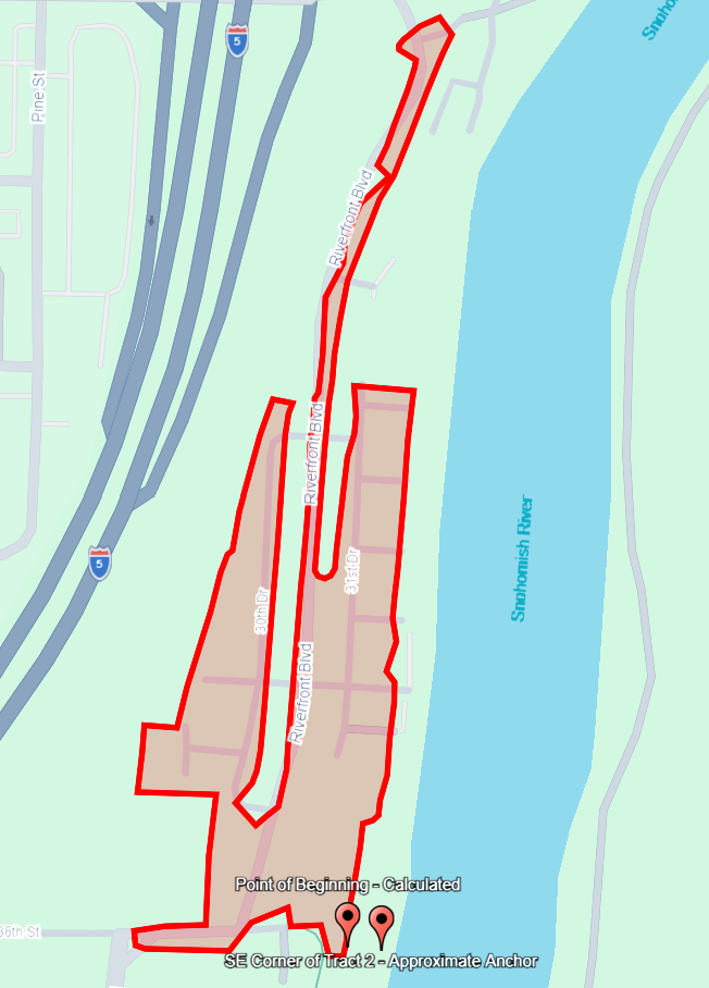
Visualizing the Safety Zone
FEMA Case No. 11-10-1975A includes a detailed "metes and bounds" description (the technical surveyor’s data) that defines exactly which land was removed from the flood hazard area. To make this easier for residents to understand, we used AI analysis to plot these coordinates onto modern maps. This process confirmed that the footprint where homes are built matches the area FEMA officially reclassified as Zone X (shaded)—the zone where mandatory insurance is removed.
Claude’s Representation of Removed Area
When provided with the metes and bounds description Claude produced the following graphic of the area removed from the hazard:

CHAT GPT’s Representation of Removed Area
When provided with the metes and bounds description Chat GPT produced the following Google Earth KML of the area removed from the hazard when we also provided it a definition of the “SE Corner of Tract 2” as the approximate intersection of 36th Street and the Western shore of the Snohomish river (47°58'12.63"N 122°11'20.13"W). We believe the referenced Tract 2 is found in the 2004 Boundary Line Adjustment reference in the FEMA letter’s legal description (Snohomish County Recorded Document Number 200402195093**)
While not the exact findings and representations from a licensed surveyor we’d prefer, these appear to provide reasonable certainty of the removed area for those who are experts in interpreting metes and bounds descriptions in a more time and cost effective manner.
What This Means for You
- No Mandatory Federal Insurance: Because the homes sit on engineered fill above the base flood elevation, federal law does not require you to carry flood insurance.
- Optional Coverage: Lenders still have the final say, and some residents may choose a "Preferred Risk Policy" for peace of mind, which is often much more affordable than standard floodplain insurance.
- Preserved River Areas: The river-side strips outside the community footprint remain in the regulatory floodway to protect the natural ecosystem.
Professional Disclaimer
While we are dedicated to helping our community, we are not attorneys, surveyors, or flood experts. This report is shared for informational purposes without warranty or guarantee. We encourage all interested parties to use these FEMA case numbers to conduct their own due diligence prior to any financial or real estate decisions.
Questions & Contact
If you have questions about this research or need help navigating real estate in The Towns at Riverfront, please reach out. We are here to help you get the clarity you need.
Phone: (206) 489-4920
Email: Jamie@reecehomes.com
More Information on the Community
Towns at Riverfront sits on roughly 17 acres along the Snohomish River in Everett, on land that was industrial for most of the twentieth century. The original parcels were platted in the 1890s as part of the Everett Land Company's First Addition (1891) and the J.S. Sines Acre Tracts (1896), and for decades the site operated as a pulp and paper mill — most recently as the Kimberly-Clark / Simpson "Eclipse" mill complex on the riverbank just below downtown Everett. The mill closed in the early 2000s, and the City of Everett began assembling the parcels for redevelopment, formalized through a Boundary Line Adjustment in 2004 (creating "Tract 2," the main developable parcel) and another in 2006.
Because the site sat in the FEMA Special Flood Hazard Area of the Snohomish River and on a former industrial brownfield, redevelopment required a long environmental and regulatory runway. Between 2008 and 2009 the City of Everett executed a Property Disposition Agreement, a Mill Property Environmental and Indemnification Agreement, a non-landfill site utility easement covering the legacy landfill gas, leachate, and groundwater monitoring systems, a mitigation agreement, and a Memorandum of Development Agreement — the package that allowed a private developer to build on a remediated mill site. The City also published Riverfront District Design Guidelines in November 2008 to govern the master-planned community, calling for engineered stormwater (rain gardens and bioswales), an enhanced ordinary-high-water buffer along the river, and a public riverfront trail.
A pivotal step came on February 14, 2012, when FEMA issued Letter of Map Revision Based on Fill 11-10-1975A. After the developer placed engineered fill raising lot elevations to roughly 13.9–16.9 feet (NGVD 29) — above the base flood elevation of 13.8–14.1 feet — FEMA officially removed the developable footprint from the Special Flood Hazard Area, reclassifying it as Zone X (shaded). Portions of the river-side property remained in the regulatory floodway, but the buildable interior was now outside the federal flood-insurance mandate.
The original developer's interests passed to Polygon Northwest (Polygon WLH, LLC) through a Mill Assignment and Assumption Agreement recorded October 7, 2014, and Polygon's affiliate Riverfront MF, LLC carried the project to completion. A wetland and ordinary-high-water buffer enhancement plan was finalized in March 2015 (plantings, large woody debris placement, critical-area signs, and a five-year monitoring program along the river), the Declaration of Covenants, Conditions and Restrictions for "The Towns at Riverfront" was recorded October 26, 2016, and the final plat creating 190 townhome lots was recorded November 21, 2016. Construction and sales ran through 2017 and 2018; per the resale disclosure, the declarant transferred control of the homeowners association to the unit owners in 2018. Today the community is 190 fee-simple townhomes managed by MacPherson's Community Management, with the HOA owning and maintaining the private streets, the rain-garden stormwater facilities, and the river-edge open space and OHW buffer that fronts the public riverfront trail.


